
Some links on this page are affiliate links. If you book through them we may earn a commission, at no extra cost to you.
The short answer
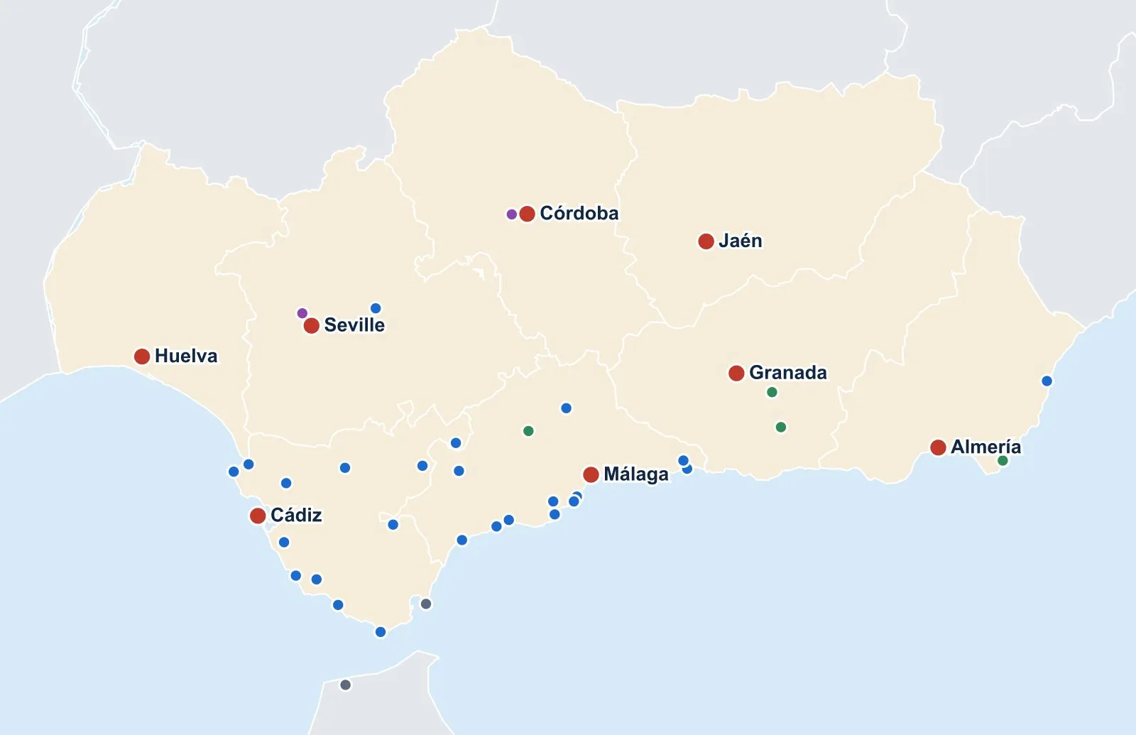
Andalusia is the southern tip of Spain: eight provinces between Portugal, the Mediterranean and the Atlantic, with Seville as its capital. The map below shows every city, town, beach, nature area and sight we have a guide for. Tap a pin to open the guide, or use the buttons to filter by type and zoom in on the coasts.
Interactive map of Andalusia
Tap a pin to open its guide. Use the buttons to filter or zoom in.
Boundaries: IGN (via es-atlas, CC BY 4.0) and Natural Earth.
Every place on the map
Seville
- Seville
- Things to do
- Real Alcázar
- Alcázar tickets
- Cathedral and Giralda
- Cathedral tickets
- Plaza de España
- Setas de Sevilla
- Triana
- Santa Cruz
- Free things to do
- Seville with kids
- Where to eat
- Where to stay
- Best time to visit
- Seville city break
- Day trips
- Casa de Pilatos
- Torre del Oro
- Parador de Carmona
- Where to eat in Carmona
- Carmona Roman Necropolis
- Carmona day trip
- Osuna day trip
- Itálica day trip
Granada
Málaga
Cádiz
Huelva
Almería
Gibraltar
Morocco
Andalusia at a glance
- Where: the south of mainland Spain. Portugal lies to the west, the regions of Extremadura and Castilla-La Mancha to the north and Murcia to the east. Morocco is about 14 km across the Strait of Gibraltar.
- Two coasts: the Atlantic from the Portuguese border to Tarifa (Costa de la Luz), and the Mediterranean from Tarifa to Almería (Costa del Sol and further east, Costa Tropical and Almería’s coast).
- Mountains: the Sierra Nevada above Granada, with Mulhacén (3,479 m), the highest peak in mainland Spain. Lower ranges such as the Sierra de Grazalema and the Serranía de Ronda hold most of the white villages.
- The Guadalquivir valley: the great river runs from the Jaén hills through Córdoba and Seville to the Atlantic near Sanlúcar de Barrameda. Most of the big inland cities sit on it or near it.
- Size: about 87,600 km², roughly 17% of Spain.
- Population: about 8.7 million, the most of any Spanish region.
- Capital: Seville.
The eight provinces
Each province is named after its capital city.
| Province | Capital | Best known for | Our guide |
|---|---|---|---|
| Seville | Seville | Real Alcázar, cathedral, flamenco, Holy Week | Seville |
| Córdoba | Córdoba | The Mezquita, flower-filled patios, Medina Azahara | Córdoba |
| Granada | Granada | The Alhambra, Sierra Nevada, the Alpujarras | Granada |
| Málaga | Málaga | Costa del Sol beaches, Ronda, Picasso | Málaga |
| Cádiz | Cádiz | Costa de la Luz, sherry in Jerez, white villages | Cádiz |
| Huelva | Huelva | Doñana, long Atlantic beaches, Iberian ham | Huelva |
| Jaén | Jaén | Olive groves, Úbeda and Baeza, Cazorla | Jaén |
| Almería | Almería | Cabo de Gata, the Alcazaba, desert film sets | Almería |
Most first-time visitors spend their time in the western and central provinces: Seville, Córdoba, Granada, Málaga and Cádiz. Huelva, Jaén and Almería are quieter and reward a second trip.
Driving distances between the main cities
Distances are by road and rounded. Times are approximate and assume no traffic; allow more in summer on the coast and around Seville and Málaga.
| Route | Distance | Driving time |
|---|---|---|
| Seville – Córdoba | 140 km | about 1 h 30 |
| Seville – Granada | 250 km | about 2 h 30 |
| Seville – Málaga | 205 km | about 2 h |
| Seville – Cádiz | 125 km | about 1 h 30 |
| Seville – Huelva | 95 km | about 1 h |
| Seville – Faro (Portugal) | 200 km | about 2 h |
| Málaga – Granada | 125 km | about 1 h 30 |
| Málaga – Córdoba | 160 km | about 1 h 45 |
| Málaga – Ronda | 100 km | about 1 h 45 |
| Granada – Córdoba | 200 km | about 2 h 15 |
| Granada – Almería | 165 km | about 1 h 45 |
| Granada – Jaén | 95 km | about 1 h |
| Cádiz – Tarifa | 100 km | about 1 h 15 |
By train: the high-speed line links several of the big cities faster than the car. Seville to Córdoba takes about 45 minutes, Córdoba to Málaga about an hour, and Madrid to Seville about 2 h 30. Granada and Cádiz have slower connections, and the white villages and most beaches are much easier by car. If you are driving, compare prices for car hire at Málaga airport, the airport with the widest choice, and read our guide to car hire in Andalusia.
Andalusia is bigger than it looks
At about 87,600 km², Andalusia is almost the size of Portugal (about 92,000 km²), and bigger than Belgium and the Netherlands put together. From Huelva in the west to Almería in the east is roughly 500 km by road, around five hours of driving.
In practice, that means you cannot see it all from one base. Pick two or three areas for a week, and use day trips for the places in between. The map’s zoom buttons help here: the Costa del Sol, the Cádiz coast and the Seville–Córdoba area each make a good cluster.
How to use the map to plan a trip
- Plan a route: our Andalusia road trip links the big cities, the white villages and the coast in one loop, with days and driving times.
- Choose a base: where to base yourself in Andalusia compares Seville, Granada, Málaga and the coast.
- Pick the highlights: start with the best places to visit in Andalusia, then filter the map by “Cities” or “Towns & villages”.
- Villages: the white villages cluster between Ronda, Grazalema and Arcos de la Frontera, which is why the “Cádiz coast” zoom is useful.
- Beaches: the “Coasts” filter shows both shores. The Costa del Sol has resort towns and calm water; the Costa de la Luz has wide, wilder Atlantic beaches.
- Timing: check the best time to visit Andalusia before you decide between inland cities and the coast. Inland summers are very hot.
Can I print it? The list under the map, “Every place on the map”, groups every place by province with a link to its guide. Print it or save it as a PDF and use it as a checklist as you plan.
FAQ
What are the eight provinces of Andalusia?
Almería, Cádiz, Córdoba, Granada, Huelva, Jaén, Málaga and Seville. Each is named after its capital city.
What is the capital of Andalusia?
Seville. It is also the largest city in the region and home to the regional government, the Junta de Andalucía.
How far is Seville from Granada?
About 250 km by road, around 2 h 30 by car on the A-92. There are also direct trains and buses, which take around 2 h 30 to 3 h.
Which is the best base for exploring Andalusia?
For a first trip, Seville for the west and Granada or Málaga for the east. Málaga has the biggest airport and easy links to Granada, Córdoba and the Costa del Sol. See where to base yourself for the full comparison.
Is Gibraltar part of Andalusia?
No. Gibraltar is a British Overseas Territory at the southern tip of Cádiz province, bordering the Spanish town of La Línea de la Concepción. It is on the map because it is an easy day trip from the Costa del Sol and the Cádiz coast.
How many tourists visit Andalusia each year?
In 2025 Andalucía received 14,466,171 international tourists. The Andalusia tourism statistics page has the numbers by topic, with a map of hotel stays by province.